1.36
billion Km3 of water exists on the Earth
97.2% ocean
2.1% ice cap and glaciers
0.65% in the freshwater reservoar (atmosphere, lakes,
rivers, groundwater)
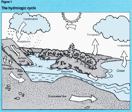
The
unending circulation of the Earth’s water supply is the so called water cycle.
The cycle itself is powered by the heat of the sun and gravitation
Figure
is from http://www.und.nodak.edu/instruct/eng/fkarner/pages/cycle.htm
Water
from the ocean and from the land is continuously evaporating into the
atmosphere, where it is transported by wind. Than clouds
are forming followed by precipitation.
Distribution
of precipitation
1. part
of the water soaks into the ground (infiltration);
2.
other part after big rains runs off (runoff)
3. Some
evaporates from the surface,
4. some
will be adsorbed then released by plants (transpiration)
3
and 4 together is called Evapotranspiration
Some
of the water can be stored on the surface for a while as snow (in glaciers)
Running
water may have the largest influence on human life.
1.
drinking water
2.
energy
3.
travel
3.
irrigation
Running
water is divided into two big group:
1.
Unconfined flow
SHEETFLOW (water flowing on the surface)
usually depend on the infiltration capacity of the bedrocks.
(after a while sheetflow will distribute into tiny
channels RILLS).
2.
Confined flow (STREAM)
In Confined flow or
stream water flows in channels, which are long narrow depressions eroded by the
river or flow into the underlying rocks.
At
the HEADWATER PART of the stream it
has a typical V shape,
where the stream occupy
the bottom of the channel.
There is absolutely no floodplain.
At
the MOUTH of the stream, it is flowing on
a broad flat-floored valley. Here the
stream channel is surrounded by
wide floodplains.
The
stream usually stays in the CHANNEL, where the side of the channel is called
STREAMBANK
FLOW
in the channel can be LAMINAR or TURBULENT
Laminar
flow is usually slow and particles are moving straight, parallel with the
stream banks:
In
Turbulent flow water flows in erratic fashion that is often characterized
by swirling, whirpool-like eddies.
Factors
affecting stream erosion, and deposition:
1.
Velocity
2.
Discharge
1.Velocity
The
speed at which water in a stream travels is
called stream velocity. (moderately fast (3 miles/hour) Fast (15 miles/hour)
Max.
velocity in a channel usually is close to its middle (Friction is the smallest
here). If there is a curve the centrifugal force pulles the highest velocity to
the outer part of the curve!!!! Changes the channel shape!!!
HIGH
VELOCITY:
River
erode and transport sediment
LOW
VELOCITY:
Deposition
happens
VELOCITY
of a stream IS CONTROLLED BY:
a. Gradient
downhill slope of the bed. (Feet/miles; or %)
G=difference in elevation
(feet) *
100
distance in course (feet)
Ex:. Changing gradient strongly influence wether the river
eroding or
deposite.
b. Channel shape and roughness
As the water flows it wets the channel, and between the bank and the
water there is
friction. The larger the channel the larger the bank, the larger
the friction.
Friction slows down the flow.
Roughness has the same affect. In smooth channel water flows
faster. (Changes shape as it flows on
different rock types.)
2.DISCHARGE
The
discharge of a river is the volume of water that flows through at a certain
point in a unit of time.
Discharge
(m3/sec)= channel with(m)*channel depth(m)*velocity (m/sec)
MISSISIPI
D=17,715 m3
Amazon
10 times more than Mississippi
DISCHARGE
IS INCREASING DOWNFLOW
ST
Streams usually cut their own valley by deepening and widening it for long time
Erosion
can happen in three ways.
1.
Hydraulic action (ability of the flowing water to pick up and move sediment
2.
solution (carry chemicals in solution)
3.
abrasion (grading, carving of river bed rocks)
Potholes (abrasive action of sediment load makes these
holes).
The
sediment in a river can be carried as
1. bedload
Large or heavy
sediment particles that traven on or near the stream bed, and move by traction
or saltation
Movement by rolling, sliding or draging is called TRACTION
2.Suspended load
Sediment which is carried in the flow all the time
3.Dissolved load
chemicalias in the stream
The
max. sized sediment in the stream that the river can carry define its COMPETENCE,
a factor related to flow velocity. CAPACITY on the other hand is the
measure of the total load the stream can carry.
Stream
Transportation of sediment
RIVERS
IN US. CARRY 250 MILLION TONS of SOLID LOAD
300
MILLION TONS of DISSOLVED LOAD.
ALLUVIUM
(river deposits)
BAR
FLOODPLAIN DEPOSITS
BAR
IN A CHANNEL
IN THE MIDDLE OR THE SIDE OF THE RIVER (CAN
MOVE)
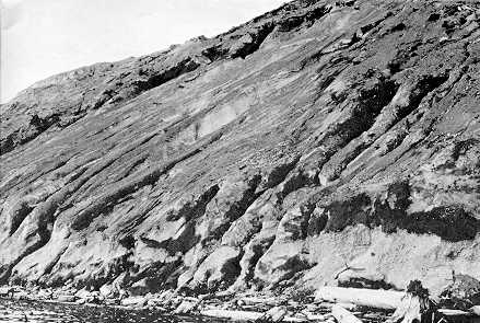
ALLUVIAL
FANS
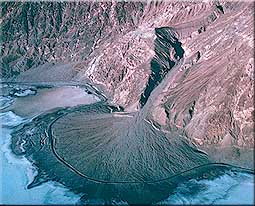
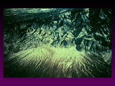
NETWORK
OF INTERCONNECTED RIVULETS AROUND
NUMEROUS BARS.
MAINLY
IN HIGHER MOUNTAINS WHEN RIVER ENTERING TO FLAT AREA.
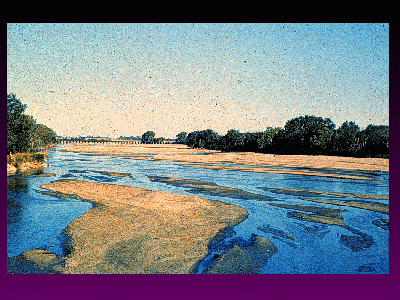
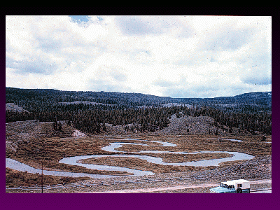
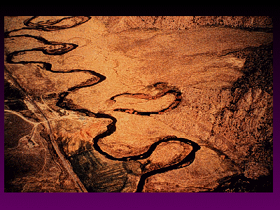
MEANDERING
STREAM AND POINT BAR
FLAT, SLOW FLOWING RIVER
EROSION IN THE OUTSIDE CURVE,
DEPOSITION
ON THE OPPOSITE SIDE.
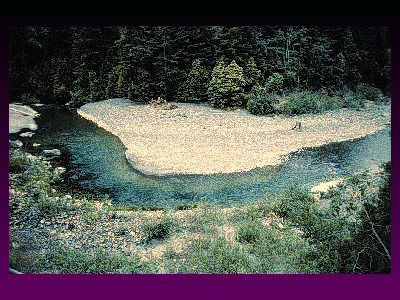 Point
bar
Point
bar
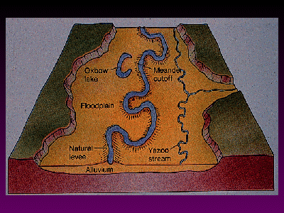
CUTOFF,
OXBOW LAKE
FLOOD
PLAINS
NATURAL
LEVEES
DELTAS (WITH LOTS OF DISTRIBUTARIES) DELTA SHAPE
NILE
RIVER
NIGER
RIVER (NIGER)
THE
STREAM AS A SYSTEM
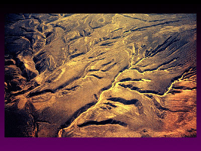
DRAINAGE
BASINS
Each
stream has a drainage basin.
Drainage
basin is the total area drained by the given stream and its tributary
Tributary
is a small stream flowing into a larger one.
Mississippi
river’s drainage basin contain 1/3 USA, together with its tributary channels
such as Ohio and Missouri rivers
DRAINAGE
DIVIDE
A
ridge or strip of high ground dividing one drainage basin from the other.
ex.
CONTINENTAL DIVIDE
streams
flowing to the PACIFIC from
streams
flowing to the Atlantic and Gulf of Mexico
WESLEY
POWELL (1875) REALIZED, THAT THERE IS A DOWNWARD LIMIT OF EROSION, WHICH HE
CALLED BASELEVEL.
Sea
level = ULTIMATE BASE LEVEL
Lake
level = TEMPORARY BASE LEVEL
THE
CONCEPT OF GRADED STREAM
WHEN
A STREAM JUST BEGIN TO DOWNCUT ITS LONGITUDINAL PROFILE IS IRREGULAR, WITH
RAPIDS AND WATERFALLS ALONG ITS COURSE.
UNGRADED
MOST
OF ITS ENERGY IS USED FOR
DOWNCUTTING, THE
IRREGULARITIES (SMOOTHING).
GRADED
AS
THE STREAM SMOOTHES ITS COURSE INTO A CONCAVE UPWARD SHAPE,
IT BECAMES GRADED.
BALANCE
BETWEEN TRANSPORTING CAPACITY AND SEDIMENT LOAD AVAILABLE
LARGE
SCALE EROSION
1.LATERAL
EROSION
WIDENING OF THE CHANNEL BY ABRASION OF BANKS +MASS
MOVEMENT ALONG SIDES
2.
HEADWARD EROSION
SLOW UPHILL GROWTH OF THE CHANNEL
3.
REGIONAL EROSION
PENEPLAIN (FLAT ERODED AREA)
THE
EVOLUTION OF A RIVER CAN BE DIVIDED INTO THREE
STAGES:YOUTH,
MATURITY, AND OLD AGE
-DOWNCUTTING YOUTH
-LATERAL EROSION MATURE
-PENEPLAIN (FLAT ERODED AREA) OLD
DRAINAGE
PATTERNS
-DENDRITIC PATTERN (IRREGULAR BRANCHING)
-RADIAL
-RECTANGULAR
PATTERN