One
Of The Most Important Source Of Drinking Water Is Lying Beneath The Surface Of
The Earth And Is Called GROUNDWATER
SOURCE
OF GROUNDWATER IS RAIN AND SNOW.
About
15% of all the precipitation ends up as groundwater.
The
whole graundwater would make a 10m deep lake which would cover the earth’s
surface.
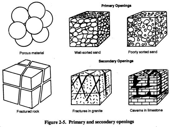
Porosity
It is the percentage of rock’s volume that can hold
water. Almost every kind of rock can hold some water.
Primary
porosity
It is depend on size, shape and arrangement of the particles in the rock.
Most igneous and metamorphic rocks have small primary porosity however it can be increased by fracturing, or weathering., or solution.
Figure
from:http://www.adtdl.army.mil/cgi-bin/atdl.dll/fm/5-484/Ch2.htm
There
are rocks such as conglomerate, sandstone, limestone which tend to have large
porosity and can hold a considerable amount of water. Originally loose sediment
have much higher porosity which can be loosen by compaction and so on.
The
capacity of the material for transmitting fluid is called its PERMEABILITY.
Permeability
depend on not only on porosity, but also on the size and interconnection of the
pores in the rock.
Shale:
probably has more pore space than sandstone, however the permeability is small
because the pores are too small and there is no interconnection between them. On
the other hand if the pores are too small there is a molecular interaction
between the mineral and water, so the water becomes unremovable.
Many
areas such as Georgia depend on fractured reservoirs for their drinking water.
flow
velocity: 1m/day!!!!! to 1m/year (the highest ever measured in US. is 250m/day
Permeable
layer transporting water : AQUIFER
aqua:
water
best:wellsorted
and well rounded gravel
Impermeable
layer preventing water transport called:
AQUICLUDE
Aquitard:
Transition between aquifer and aquiclude
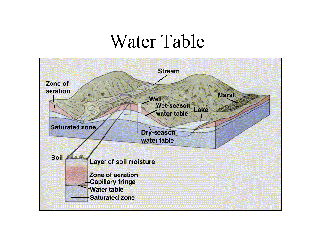
WATER
TABLE
As the
water from rain moves subsurface and adheres downward:This zone is called:
ZONE OF
AERATION
Water
here is called: SUSPENDED WATER
Pore
spaces in this zone are filled by both air and water
CAPILLARY
FRINGE:
It is
the zone just above the base of zone of aeration. Water in this zone moves
upward because of the surface tension. This phenomena can be seen with larger,
and small tubes put into the water.
Figure
from:http://www.adtdl.army.mil/cgi-bin/atdl.dll/fm/5-484/Ch2.htm
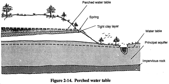
Perched
water table (above the main wt)
Figure
from:http://www.adtdl.army.mil/cgi-bin/atdl.dll/fm/5-484/Ch2.htm
Usually
the shape of the water table is a replica of the surface. Therefore it is higher
underneath mountain, or hills, and lower beneath valleys. The unequality of
water table also caused by different rainfall pattern, different permeability.
During dry season it drops, so probably shallow wells would dry out.
Recharge:
enter to the system
Discharge:
leave the system
The
water moves very slowly by gravitation higher elevation areas toward lower
elevation.
Sometimes
the water can move upward, against gravity, because of the pressure difference.
The
pressure difference in groundwater is created by the height difference of the
groundwater table relative to different areas.
Underneath
of hill the pressure is higher than in lower areas such a stream channel, so the
water will move to the lower pressure areas
Darcy
(French engineer in middle of nineteenth century)
He
realized, that if the porosity and permeability remains the same, then the water
moves faster if the slope of the water table is steeper.
The
slope of the water table is the hydraulic gradient. He defined the
relationship of the velocity of watermovement and height of water table.
V = Kh/l
V=
velocity
h=hydraulic
head (vertical difference between recharge and discharge)
l=length
of the flow
The
relationship between stream and ground water level:
EFFLUENT:
surrounding
grondw. table is higher than the stream, the stream is supplied from
groundwater!! (humid climate)
INFLUENT:
Where ground
water level is lower than the stream (arid climate)
NATURAL
AND ARTIFICIAL DISCHARGE:
Natural
discharges:
SPRING:
Water
table or perched water table intersect with surface, and water will flow out
from the ground. (superstitious people thought that they had power for treating
and healing)
ARTIFICIAL
discharge
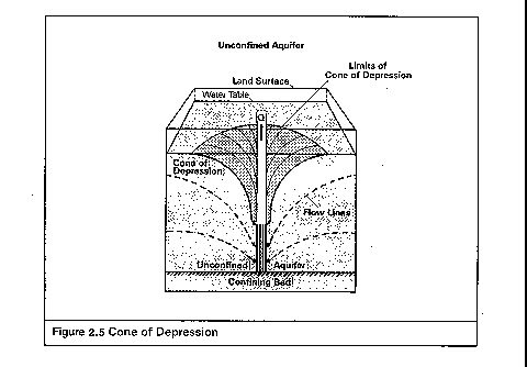
Water
wells:
digged,
or drilled openings for water. Most wells have to be pumped to bring water out.
If it is pumped the ground water is lowered around.
CONE OF DEPRESSION. = can cause dry well.
Successful
wells:
ARTESIAN
SYSTEMS
This
word comes from French town where the first artesian well was drilled. (1126) it
is still flowing.
The
term means:
If the
ground water is confined and build up high hydrostatic pressure (fluid
pressure). If we drill a well into an aquifer like this, the water will flow out
by itself.
To develop an artesian system there are three geologic factor we need:
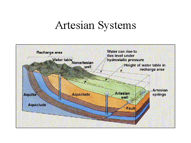
1. The
aquifer has to be confined (aquiclude above and below, to prevent water from
escaping)
2. The
sequence has to be tilted, which means it has an access to recharge
3.
There is sufficient precipitation to fill the used water.
Artesian
pressure surface:The surface defined by water table in the recharge area. In any
well the water would rise exactly to the water pressure surface.
FLOWING
ARTESIAN WELL
NONFLOWING
ARTESIAN WELL
City
water system:
ARTIFICIAL
ARTESIAN SYSTEM
Water
tower will make a water pressure surface, that is why water flows freely from
taps.
HOT
SPRINGS AND GEYSERS
In
recent active volcanic areas the rocks stay hot for thousands of years. If
groundwater percolate through
these
rocks are heated and will be hot spring or geysers when returned to the surface.
Most of
the hot spring’s heat source is igneous activity, but it can be just deep
water warmed bec. gg.
GEYSERS
The
groundwater percolating down into the fracture network, and becomes heated as it
comes into contact with hot rocks. When the water gets near to its boiling point
, a slight rise in temperature, or a little escaped gas will instantly change
the water to steam. The expanding
steam will rise the water above quickly above the surface. = geyser eruption.
After eruption the new groundwater relatively cold seeps to the system.
Minerals
in hot springs and geysers!!!!! Treatment.
Precipitation
CaCO3 -- travertino
SiO2 geyserite
Geothermal
energy!!!!!!
Iceland
New-Zealand
Hungary
Karst
systems
Limestone
areas under humid climates!!!!!!
water + carbonic acid
In
regions where bedrock is limestone the surface can be pitted with numerous
depressions, that vary in size and shape. These depressions are called
SINKHOLES.
Sinkholes
are formed
1. by the dissolution act of seeping groundwater and rainwater. (gentle sloping crater)
Later
these openings are enlarged and filled by soil.
2. by collapse of cave roof. (steep slope crater) Danger!!!!!!
KARST TOPOGRAPHY (groundwater erosion)
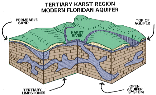 From:http://www.dos.state.fl.us/dhr/bar/hist_contexts/karst.html
Italy
Tenesse,
Kentucky, Florida, Virginia
What do
we NEED
1.
LIMESTONE
2. RAIN
A Karst
area is characterized by numerous caves, springs, sinkholes, solution valleys,
and dissapering streams. (staining)
In dissapering
streams water flow on the surface for a short distance and disappear in a
sinkhole.
Forming
of caves!!!!!!!!!
Cave:
caverns:
Deposits
stalactite
(dripstone)
sodastraws
stalagmite
column
travertine
terrace
Minerals
Mainly CaCO3: calcite, aragonite
rarely gypsum
white,
reddish, blacksish, (historic fires)
PROBLEMS
WITH GROUNDWATER
1.
Lowering water table
arid
areas
withdrawing
groundwater at a higher rate than it is replaced will generally lower the
groundwater level.
(HIGH
PLAIN; Nebraska, Kansas, Oklahoma, Texas)
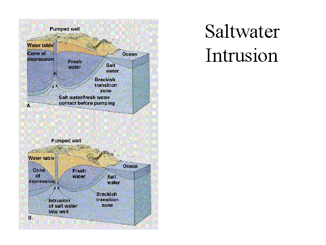
2.
Saltwater incursion
Long
Island (New York, 1960)
Fresh
groundwater which is less dense than saltwater
forms a
lens shaped body above underlying saltwater. The weight of freshwater create a
pressure on the saltwater. If some of the freshwater is removed by pumping it
forms the Cone of depression and it will make
cone of ascension in salty water (salt water starts to go to the well),
so water will be contaminated with salty water. It can be prevented by using
recharge wells in the area.
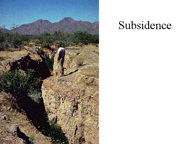
3.
Subsidence
In
poorly consolidated sediment groundwater pumping creates sinking of the surface,
because the water had pressure, which kept the pore space in the sediment. (San
Joaquin Valley California Between 1929, 1975 9m of subsidence happened; New
Orleans; Lousiana; Las Vegas 8.5 m). (Tower of Pisa)
4.
Groundwater contamination
DO NOT
FORGET GROUNDWATER MOVES SLOWLY. IT IS HARD TO CLEAN
Non safe disposal of waste material
-sewage (septic tanks)
-landfills
-toxic disposal sites
-agriculture