Chapter 15.
Shorelines
The waters of the oceans are constantly in motion. This movement is much better recognisable along the shore, which is the dynamic interface between land and ocean called coastal zone.
Here we can observe waves, tides, and the ever shaping
shoreline
Waves,
currents and tides
Waves
The energy of waves are coming from wind. When wind blows
over the water, some of the energy is transferred to the water surface and its
undulation is forming the waves that move through the water.
Height of wave
The vertical distance between the crest and the trough.
In the ocean normal waves are 1-15 feet high, but storms
such as hurricans can induce waves with 50 feet height. The highest wind wave
ever measured was 112 feet.
Crest
high point of a wave
trough
low point of a wave
Wavelength
The horizontal distance between two wave crests.
In most of the ocean the lengtsh of wind waves are 130-1300
feet (40-400m) and their speed is
15-55 miles/hour in deep water.
Wave period
It is the time passing between two crests passing through
at a stationary point.
Factors, influencing
wave height, length, and period
1. wind speed
2.the length of the time the wind has blown
3.The fetch, or distance that the wind has travelled across the open water.
The stronger the wind the steepness and the height of the waves increase till a critical point, where breakers or white caps form. Whitecaps are the places to loose energy, and waves can not grow higher.
When wind stops or change direction the waves that were
created will continue to travel independently from local winds. Gradually they
will change into swell.
Swell
Lower, longer waves, carrying storm energy to a distant
shore.
Movement of the wave
It is important to know that the wave form is moving, not
the water itself. Each water particle moves in a circular path as the wave
passes through, and they return to their original position. The diameter of the
circular orbit of the particle on the surface is equal with the wave height. To
larger depth this diameter becomes smaller, and dissapear at the depth of 1/2
wavelengthWhen the particle is in the crest it moves with the wave direction,
when it is in trough it moves opposite to the wave direction. This is called wave
oscillation.
As long as the wave
moving in deep water, it is not affected by water depth.
When it approaches
to the shore it starts to be affected by the bottom.
Wave
base
When the botton is
equal to the 1/2 wavelength, the wave starts to feel the bottom. When it happens
the circular water movement becomes oval, the wave slow down and its length
decreases. Along with this the height of the wave increases and becomes steeper
till it reaches the critical point and breaks. (surfing) The wave oscillation
becames wave translation when the water itself starts to move and advances up to
the shore.
Surf
The zone of
turbulent water created by breaking waves is called surf.
swash
is the sheet of
turbulent water collapsing from braking waves and advancing upon the beach.
Backwash
The water moving
backward to the ocean.
Wave refraction and
coastal currents
Usually waves strike
a coast at an angle, when part of the wave entering to the shallow water sooner
than the rest. The other part of the wave is still in deeper water, so moving
fast and pivots around the slow shallow water segment (turning marching band).
This wave refraction or banding causes the last arriving portion of the wave to
be almost parallel to the coast before braking. (From 50-60° to less than 5°)
As each of them
brakes and strikes the coast its surf pushes the swash ahead of it up the beach
at a small angle. Backwash then returns to the sea perpendicular to the
shoreline.
Wave impact along an
irregular coast is different because of the refraction. The headland would be
more attacted than the bay. So arosion of headlend, and deposition in the bay
will eventually straighten the shoreline.
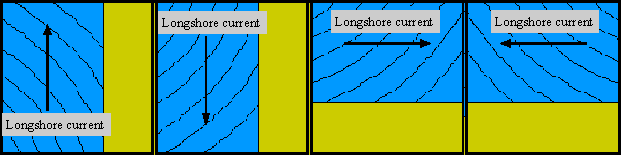
Longshore
current
The combined swash
and backwash of the waves creates a turbulent current, that moves sediment or
swimmers along the shore nearly parallel to the shore line
After:http://www.gvsu.edu/videticp/longshore.htm
Speed of this
current is 0.25-1m/sec. It can be higher than this, and be powerful enough to
carry sediment in suspension into long distances (some sand on the outer banks
of North carolina is coming from the Rocky coast of Maine, 1500 km North).
The width of
longshore current is equal to the width of surf zone.
Rip current
This is known by
swimmers as undertow, flow straight out to sea, channelled water and sediment
movement perpendicular to shoreline. This occur when water in the surf zone
accumulates moves back seaward. They usually interfere with incoming waves. It
is easy to see them, because of the discoloration. (rip currents have lots of
sediment they would be darker). Another sign, that at rip currents incoming
waves would break earlier (Swimmers caught in these should swim parallel with
the shoreline to get out) DO NOT TRY TO STRUGGLING AGAINST THE CURRENT!!!!! For
people surfing it is good to travel with seaward.
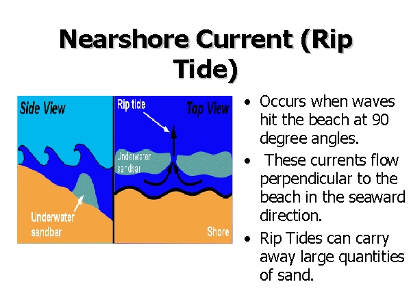
After: http://marine-science.sc.edu/classes/msci505/penn/sld008.htm
TIDES
Tides are twice a
daly rise and fall of the surface of oceans and large lakes, which moves the
shorelines alternately landward and seaward. For the water to rise in one place
they must be pulled away from another part of the earth.
Causes:
1. The gravitational
pull of the moon and the sun and
2. The force
produced by the rotation of earth-moon system.
The tides are
response to gravitational and centrifugal forces. The gravitational attraction
of the Moon periodically reinforced or opposed by the sun, pulls a buge of water
toward it, while the centrifugal force of rotation of the earth-Moon system
forces an opposing mass of water to be flung outward on the opposite side of the
earth. The earth rotates through these two bulges every 24 hours; thus there are
two high and two low tides each day(Atlantic) (SEMIDIURNAL).
Some places on the
earth especially where the water body has restricted access to the open ocean
such as Gulf of Mexico, Caribbean sea, there is just one high and low tide. This
type of tide is called DIURNAL . There are places when the time between two high
is not the same, called MIXED TIDAL PATTERN. (Pacific)
Tidal interval
Time between two
high tide
Tidal range
The difference
between sea level at high and low tide. It is varies from place to place in
response to the factors such as coastline, the depth of water, accessto the
ocean, and the topography of the ocean floor. (average on Pacific coast 1.5-3m)
Florida bay less than 0.7m. The highest tidal range occurs in Bay of Fundy
average 15m.
Spring tide
Sun has a tidal
effects also because of its gravitational force, but since it is much further
away it is less important than the moon. However when the moon and the sun lines
up (full moon, new moon ), it will result in an abnormally high and low tide
increasing the tidal range (every two weeks).
Neap tide
When the moon is
halfway on its orbit around the earth it is 90° away from the sun. This will
result in an abnormally low high tide called neap tide.
Horizontal tidal
currents
FLOOD TIDE
The tidal movement
we just described is the vertical rise and fall of the ocean water. There are
also horizontal currents, especially in bays or sounds. The flood tide is the
incaming current accompanies rising tide
Ebb tide
This accompanies
falling tide
Slack water
The time between
flood and ebb tide where there is no current
Speed of tidal
current
High 4.6 miles/hour
at Golden Gate
Could be as fast as
11miles/hour
Processes that shape
the coasts
Coastal erosion
Probably most
important source are waves where the erosion is caused by swash and backwash. It
is important because the braking waves have huge energy. the pressure of the
Atlantic waves for example 10,000 kg/m2. (1000 tons weight steel could be moved
suring storms.(abrasion)
Wave erosion is much
bigger along shores of unconsolidated sediments. It is also depend on the
orientation of the coast line relative to the prevailing wind direction.
Landforms produced
by coastal erosion
1.Sea caves
2. Sea arch
3. sea stack
Coastal
transport and deposition
When there is an
access sediemnt in the water it will start to deposit. Most of the timre it will
form BEACH.
It is defined as the
dynamic, relatively narrow segment of the coast that is washed by waves, tide.
It may contain sand, silt, or gravel sometimes even cobble depending on the
energy level of the coast. From the sand on the beach dunes often forms by wind
blowing and transporting the sediment.
Boundaries of beach
low-tide line to the
sand dune fiels, or where the permanent vegetation starts.
Parts of the beach
Foreshore
low-hightide line
Backshore
High tide line - to
sea cliff or vegetation line
Beach
face
the steepest part of
the beach
Longshore
drift
It is the movement
of sediment parallel the shore by longshore current. It happens on the beach and
in the surf zone.
This sediment after
a while will be deposited and form different forms such as
Spit
Fingerlike ridge of
sediment that extend into open water
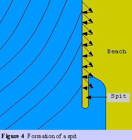
After: http://www.gvsu.edu/videticp/beach_drift.htm
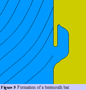
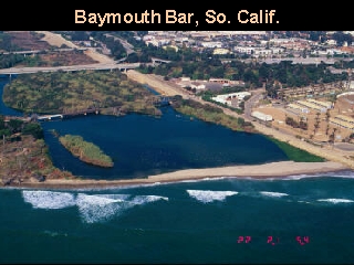
baymouth
bar
A ridge of sediment
that cuts a bay off from the ocean
Tombolo
rare, it is a bar of
sediment connecting former island to the mainland
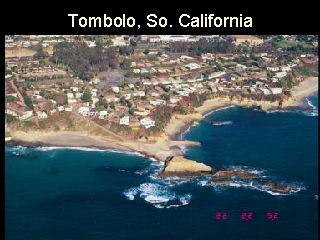
After: http://www.geo.wvu.edu/~kite/Geol221_2001Lect23Coastal/sld059.htm
Human-induced
coastal deposition
Some human-made
structure will disturb the balance between the amount of sediemnt delivered to
the shore and the amount removed by longshore currents. This cause beaches to
grow in some places and shrink in other places.
BREAKWATERS
GROINS
JETTIES
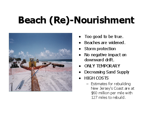
BEACH NOURISHMENT
Is replacing sand to
eroding beaches
Can causeproblems
suchs as in Miami
Sand for
replenishment was brought form Everglades
-sand silt and clay
to replace the coarse graded sediment of Miami beach. The clay silt particle
washed out from the sediment and the water became turbid and caused big damage
to the reef.
http://marine-science.sc.edu/classes/msci505/penn/sld021.htm
Types
of coasts
Primary coast
Formed by nonmarine
processes:
glacial erosion:
fjords Northeast of Atlantic(Maine)
Stream deposition:
Gulf coast of Luisiana
Carbonate reef
(Florida, Bahamas)
Secondary coast
Formed mostly by
ongoing marine processes
Barrier islands
Changing sea level
Sea level is
changing. Its cause is mostly external, but some people think that is enhanced
by human influence!!!
Global warming!!!!!
So what!!!!!
Discuss!!!!!
Ice ages!!!